Tag Archives | Google Maps

Google Maps for Android Now Helps You Avoid Traffic

The navigation products available for cell phones aren’t perfect, but there are a lot of us out there that depend on their directions to get from Point A to Point B. However, up until now the app had no way of knowing whether a road was closed or a traffic jam or accident would slow your trip down–thus, knowing traffic before you left or during your trip was a necessity.

Not any more. Google on Monday rolled out functionality in its Android app which will use both current and historical traffic data to plan routes, as well as give alternates. The Maps function could do this previously, however it was only for set conditions — i.e. the shortest route in distance or to navigate around toll roads.

Accessing the new functionality is as simple as loading the app itself — no update is required. This seems to be due to the fact that the change is not on the phone itself, but rather on Google’s servers, which the app pings to return directions to you.

The functionality will be available in both the North American and European markets where Google has access to real time traffic data. No word if this will make it to the iPhone version of Google Maps, if ever.

Have an Android phone and live in a congested area? Please let us know how the new version is working for you.

2 comments

Google's Accidental Spying Mess

For years, Google has used its squadron of Street View cars to capture imagery and 3D geometry for Google Maps and data about Wi-Fi networks that it uses in its geolocation-enabled apps. It’s been a controversial practice, particularly in Europe. And on April 27th, the company published a blog post to clear up misconceptions about its practices. The tone was very slightly edgy, and the gist was (A) we’re not invading anybody’s privacy; and (B) other people have been doing this stuff even long than we have.

Except…now Google is saying that its statement that it was only collecting SSID and MAC information from the networks it drove by is incorrect. At the request of the German government, Google examined its system more carefully. And it discovered that for the past three years, Street View cars have been accidentally using a piece of software that can pick up data being transmitted over non-password protected networks. Since the cars were in constant motion and their network-monitoring equipment changed channels five times a second, the company says it’s “typically” only picked up “fragments” of data.

Continue Reading →

2 comments

TomTom Puts the U.S. on Sale

GPS kingpin TomTom, which released its much-awaited iPhone version back in August for $99.99, has a new version out today for $49.99. The difference? The original edition (which remains available) covered the U.S. and Canada, and the new one is U.S.-only. It may not technically qualify as a price cut, since you get less for your money. But it does feel like a telling reaction to the extreme price sensitivity in iPhone appland, as well as the arrival of cheap GPS apps such as MotionX ($3.99 to buy, then $3.99 for any month when you use it).

Next question: What happens to TomTom and Navigon and AT&T and Networks and Motion and even MotionX if Google brings its free version of Google Maps with turn-by-turn directions from Android to the iPhone?

2 comments

Is TomTom Toast?

Tom Tom GPSAmong the bevy of interesting things about Verizon’s Droid smartphone is Android 2.0’s new version of Google Maps, which includes full-blown turn-by-turn GPS navigation with spoken instructions–for free. Judging from the couple of trips around San Francisco it’s guided me on so far, it would be pretty darn appealing even if it wasn’t a freebie–the directions worked, it speaks the names of streets in a crisper voice than AT&T Navigator sports on the iPhone, and I like the way it switches to a Street View photo once you’ve arrived at your destination.

Google says it’s working on bringing the new version of Maps to other devices. If it does, for-pay navigation applications will have to be radically better to compete, which is bad news indeed for all the companies charging for smartphone navigation apps–and probably even worse news for those who sell stand-alone handheld navigation devices. People are already spreading doom and gloom about the future of navigation stalwarts such as TomTom and Garmin.

There’s at least one form of dedicated navigation hardware that I hope doesn’t vanish: built-in car systems, which have nice big screens and, in some cases, user interfaces better designed for on-the-go use. And pilots, sailors, and other specialists will still want their customized GPS devices. But if we all get navigation that’s 90 percent as good as the best stuff out there for 0 percent of the price, it’s hard to see how many folks will justify paying for another gadget–especially one that may carry a monthly service charge.

Your take on the fate of GPS hardware, please:

7 comments

Google Maps Knows Where You Are

Google Maps LogoOne of the nifty new features that debuted in Firefox 3.5 last week was support for the W3C Geolocation API Specification, a Web standard that can fake a GPS-like effect by using clues such as the Wi-Fi networks you’re near to figure out your location. The only problem was that the standard isn’t yet widely supported by the Web sites and services that could benefit from it.

Chicken, meet egg: Today, Google updated Google Maps to take advantage of Geolocation.  Click on a circle on a map, and Maps will do its best to determine where you are, saving you the time of typing in an address. (I almost never use hotel-room phones anymore, but still find them invaluable because they’re usually labeled with the hotel’s street address.)

Continue Reading →

6 comments

HP Unveils a Web-Connected Printer

HP LogoHP likes it when people print. And print. And print. And I’m at an event where the company just unveiled (literally!) the PhotoSmart Premium with Touchsmart Web, a new $399 inkjet all-in-one printer. It’s got a large color touchscreen and connects directly to the Web via Wi-Fi–so you print out stuff without ever touching your PC or using a browser.

Here’s a fuzzy photo of HP printing honcho Vyemesh Joshi using the printer to browse coupons from Coupon.com and print one out–the UI looks fairly slick, like an iPhone embedded in the printer’s control panel:
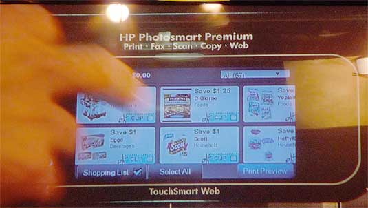
Coupon printing

So far, HP hasn’t talked too much about the technical details, but Web sites will apparently have to prepare content specifically for access via the printer–that’s not a full-blown browser that you get access to via the screen. The company has lined up a pretty impressive group of sites to endorse the printer and presumably support it: Google (with Google Maps), Coupons.com, Fandango, and Nickelodeon.

My impulse is always to be a tad skeptical of new technology products based on the assumption that there are large numbers of people out there who are itching not to use PCs. The demo is over and we’re watching a panel discussion; everybody on stage is explaining why printing is great, but they’re not saying just what’s so difficult about printing from a PC.) And $399 is potentially pricey these days for a home printer, although HP hasn’t mentioned what other features the printer has. (Joshi says the company thinks that $99 printers will have these Web features eventually.)

Actually, listening to the discussion, I think the pitch here isn’t so much that the printer eliminates the need to print from a PC–it’s that a Web-connected printer can start to reduce the need for stuff like millions of coupons being wastefully distributed via newspapers. (Sorry, newspaper publishers!) They’re talking about a day when most of the printed items in our lives might be printed on demand. That sort of makes sense, although it’s going to be a while before we get there and one printer is a very small step in that direction.

It’s an intriguing idea, anyhow, and potentially a useful one if the interface works well and lots of major companies support it. (The API is HP-only, not open; wouldn’t a standard usable by all printer makers be cooler and stand a great chance of success?)

During the on-stage demo, I wondered why HP only showed the Coupons.com app, and that one only briefly. I think I got my answer when the presentation ended and we were able to get hands-on experience with the printer. The Google Maps application was quite slow, and didn’t seem to be fully implemented; an HP representative told me that they’re still optimizing everything, so I wouldn’t judge the printer that will ship by its current state. (The Web features, incidentally, run on Linux and use a Webkit-based browser.)

The printer will ship in the Fall. Here it is:

HP Web-Connected Printer

And here’s a close-up of the screen–yes, it does look rather like a skinny iPhone attached to the front of a printer:
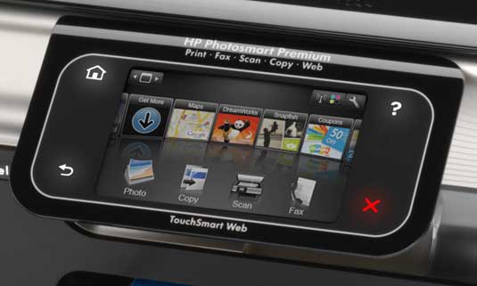
HP Control Panel

8 comments

Swine Flu Takes to Google Maps

swineflu1Whether you’re nervous about a possible pandemic or just want to stay informed, some Google Maps mashups are making it easy to track the worldwide spread of swine influenza.

My favorite, put together by Pittsburgh biomedical researcher Henry Niman, pinpoints the location of every case around the world, with colored markers denoting whether swine flu was suspected, confirmed or tested negative. Clicking on a marker brings up a short description of the case and the date of infection. When the marker has no dot in the center, it means the victim has died.

It’s a pretty easy way to get frightened.

Other maps are out there as well. The 2009 Swine Flu Outbreak Map offers a similar level of information but as a collaborative document, lending itself to more frequent updates. Meanwhile, the Guardian has posted a database of cases, encouraging readers to create their own mash-ups and visualizations.

When the world was dealing with H5N1 avian flu a few years back, Google Earth was the tool of choice, with Nature reporter Declan Butler putting together one notable example. In 2007, Google introduced My Maps, allowing for easier map creation through simple pointing and clicking. This has no doubt caused the migration of flu tracking from Google Earth to Google Maps. And it’s happening quickly, just days after swine flu hit the public spotlight.

Of course, if you’d prefer not to worry, the Internet is also full of perspective.

17 comments

UK Village Takes On Google Street View Car

Google LogoHere’s a way to let Google know you aren’t happy with their efforts to photograph your property: you try to stop them in their tracks. That’s what a bunch of residents in Broughton, Buckinghamshire, England did when they spotting one of Google’s trucks entering their neighboorhood.

According to press reports from both the BBC and Sky News among other outlets, Broughton has been troubled by a spat of burglaries in recent months, so residents have banded together to watch for suspicious vehicles.

The argument is the images taken by Google Street View cameras are an invasion of privacy, and could be used by potential burglars to scope out homes without actually having to enter the neighborhood.

Police were called to the scene, however during that time the Google employee apparently backed off and did not photograph the community. There has been no word whether Google will attempt to photograph the area again in the future.

However, the company mantains it was not breaking the law, and said it does provide a method in which concerned citizens can have themselves or their property removed and/or blurred out in Street View searches.

Click here for a BBC interview with Paul Jacobs, the resident who apparently was the first to take on the Street View car driver. What do you think?

5 comments

Don’t Fear Pegman: New Google Maps Street View is a Winner

pegmanMcCracken’s Law of Software Mascots states definitively that they’re almost always a truly lousy idea. Most of the evidence has come in the form of grating, patronizing Microsoft characters, from Bob to Clippy to Rover, the miserable mutt who shows up in Windows XP’s search. So I was alarmed when I heard that Google Maps’ amazing Street View photographic imagery feature had been updated with a new interface involving a mascot. Named Pegman. Who, in an image in the Google Blog post announcing the news, seemed to be channeling Clippy:

pegmanshy1

Continue Reading →

8 comments